Palakkad, the hilly district is devoid of any sea coast. The district set in the foot of majestic Western Ghats is unique in its geographical position, historical background, educational status and tourist attraction. The colossal Western Ghats stretch over 960 km, in length, their continuity is broken at Palakkad, known as 'Palakkad Gap' with a width of 32 km. On either side of the 'Palakkad Gap' are the imposing Nilgiris and Anamalais. The climate of the district is hightly influenced by the 'Palakkad Gap', as it enables the north - east winds to pass through it. This phenomenon gives the benefit of both south-west and north-east winds, resulting in rainfall to the district in both the seasons. The high rainfall helps the extensive paddy fields in the district and it has aptly fields in the district and it has aptly earned the epitah of "Granary of Kerala" or the "Rice bowl of Kerala". The 'Palakkad Gap' has also contributed immensely in the commercial and cultural exchanges between the State and other parts of India.
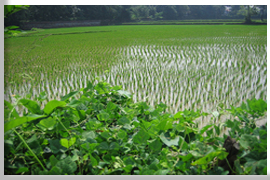
Palakkad district is predominantly an agricultural area. The main crop is paddy, which is grown in three seasons, viz., Autumn (Kanni or Viruppu), Winter (Kumbham or Mundakam) and Summer (Punja). Other crops includes, sugarcane, groundnut, arecanut, cotton, rubber, cardamom, coffee etc. Cashew nut is mostly grown in the Ottappalam and Manarghat taluks. The district has several irrigation projects and rivers. Bharathapuzha or Ponnani river, originates from Anamalai hills and is the longest river in the State, although the river has little commercial value, the people in the district hold the river in high esteem. Handloom weaving is the important traditional industry of the district.
Boundaries
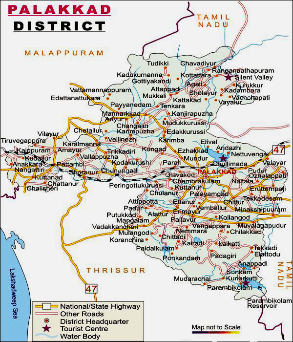
Palakkad district is situated in the South West coast of India, bounded on the North by Malappuram in the east by Coimbatore of Tamilnadu, in the South by Thrissur and in the west by Thrissur and Malappuram districts. It lies between 10°21 and 11°14 North latitude and 76°02 and 76°54 East longitude. The total geographical area of the district is 4480 sq km representing 11.53 % of the State's geographical area. The forest land per cent covers 136257 hectares.
History
Palakkad is one of the fourteen revenue districts of Kerala. Its geographical position, historical background, rural natural, educational status, tourist attractions and above all, the developmental activities that are carried out, are wide and varied.
This district, situated almost in the centre of State, has no coastal line. The district opens the State to the rest of the country through the Palakkad gap. This 32 to 40 km wide natural gap in the 960 km long Western Ghats is perhaps the most influential factor for the unique characteristics of the district such as climate, commercial as well as cultural exchanges between the State and the rest of the country. Palakkad witnessed invasions of historical importance that have left indelible impressions on the history of Kerala. Bharathappuzha, the longest river in Kerala, originates from the highlands and flows through the entire district.
The district is one of the main granaries of Kerala and its economy is primarily agricultural. Agriculture engages more than 65 per cent of the workers and 88.9 per cent of the district's population is rural in nature. The proximity and easy approach to Tamil Nadu have caused the admixture of Malayalam and Tamil culture, here.
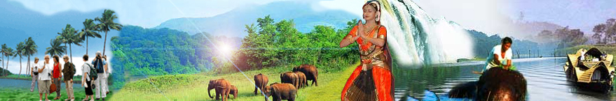
The district is perhaps the foremost in fostering Carnatic music. Great musicians like Chembai Vaidyanatha Bhagavathar and Palakkad Mani Iyer, who have enriched Carnatic music by their contributions, hailed from this district. Forests, numerous streams, several dams and the gardens in them have made this district a tourist paradise.
Palakkad is part of the erstwhile Malabar district of Madras Presidency. The district accounts for about 11.5 per cent of the total land area of Kerala, with the share of population is 8.22 per cent. The district has got two types of climates. Ottappalam, Alathur and Mannarkkad taluks are having a climate similar to that of other districts of Kerala, whereas Palakkad and Chittur are having rather a dry climate similar to Tamil Nadu. However the average rainfall is good for cultivation. There are five taluks, 163 villages , four Municipal towns and ninety Panchayaths in the district. The district is divided into 13 community Development blocks for the effective implementation of various development activities.
Palakkad is the land of Palmyrahs and Paddy fields. Along with Kuttanadu, Palakkad is major paddy growing area of the state. It is often called as the "gateway of Kerala". The Sahya ranges bordering the region and the 32 to 40 km long gap in the mountains exert a dominant influence on the climate of the region. This gap is known as 'Palakkad Gap'. In the past, this land was known as Palkkattussery. Etymologists trace the word Palakkad from Palanilam meaning the dry area. Palakkad has a long history dating back to the paleolithic period which was substantiated by a number of megalithic relics discovered from this region. It also housed the Capitals of two kingdoms such as Palakkad and Kollengode, which were in prominence till a century back.
The district has a humid climate with a very hot season extending from March to June in the Western Part of the district whereas it is less humid in the eastern sector. The most important rainy season is during South West monsoon which sets the second week of June and extends up to September. About 75 per cent of the annual rain is received during the south west monsoon period. During the period December to May, practically no rain is received. The temperature of the district ranges from 20 °C to 45 °C. The maximum temperature recorded at Palakkad was 43 °C.
Rivers
The most important river in the district is the Bharathapuzha. The tributaries of Bharathapuzha are Malampuzha, Walayar, Mangalam, Meenkara, Ayalure, Pothundy and Kanjirapuzha. There are also two tributaries of the Cauvery in Attappady hill range.viz. Bhavani and Siruvani. The other important river flows through the district is Korapuzha,. Kunthipuzha and Nellipuzha are two tributaries from Attappady and join the Bharathapuzha at Kuttippuram.